
High-Level Project Summary
In order to ensure building security, the data obtained by scanning it with the X-ray camera and infrared vision on the drone will be transferred to the relevant authorities. Aerial imagery via drones and satellites contributes to urban planning and curbing urban sprawl identifies the regions where elderly, disabled and pregnant people are concentrated, recommends increasing the public transportation services in the region to the authorized places. It is monitored 24/7 to prevent unauthorized/illegal destruction of greenery. For the elderly, children and women, a list of non-recommended regions can be drawn up, such as high crime rate, lack of greenery and distance from public institutions.
Link to Project "Demo"
Detailed Project Description
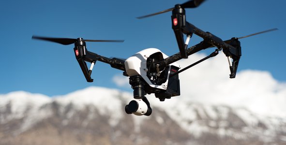
Bilnet Tech group developed a drone, satellite, website and mobile application were developed with reference to the Sustainable Development Goals. A system that can serve in many areas has been developed with data and aerial images obtained through drones and satellites. The drone and the mobile application are connected via satellite. The drone will have a high resolution (8K) camera, X-ray, temperature and pressure sensors, infrared vision and thermal camera. The body is planned to be made of a non-electrical, water, dust and wind resistant material, while it is also expected to protect the drone's power source, the solar panel. As an alternative energy and charging source, we plan to charge the station using solar panel. This will be done by determining the location of the most intense sunlight. We plan to have the control fully autonomous, but still having a manual control center is important for safety. The drone is designed considering air friction, standard atmosphere and wing structure, the maximum desired altitude is 3000ft.
What is Tech City Project?
Tech City Project is the use of High Technology Drones and Satellites to improve urbanization and increased welfare. This project is dominated by advanced drones, aims to prolong people’s life expectancy, prevent unplanned urbanization and provide urban security. It also aims to protect nature, predict and prevent disasters. Let’s dive deep into the Tech City Project. We are aware that the privacy of human life is very important, so we have very strict privacy policies. The project was created with reference to the Sustainable Development Goals organized by the United Nations. The project especially aims to protect the safety of the elderly, children and women. Through its aerial imaging system and satellite data, it can detect unplanned urbanization, unauthorized tree felling, unauthorized waste dumping, forest fires and environmental pollution. So how does the project save us time and provide life safety? It shows the average speed and estimated time of arrival in areas with heavy traffic. The aerial systems informs drivers about traffic accidents in the area. Offer solutions to areas with heavy traffic thanks to the artificial intelligence installed in the systems. Aerial imaging systems will inform about areas that are not suitable for living, for certain age groups (heavy traffic, lack of greenery area, high crime rate.) It will detect the deficiencies of the municipality and notify the relevant authorities (missing pavements, pedestrian crossings, worn out roads). The system prevents unplanned urbanization by drawing up the aerial layout of the whole city and prevents the construction of more incomplete buildings. Our high technology Drones contain thoroughly selected functional features.
Our drones have high resolution x-ray scanning, infrared vision, temperature sensors and night vision. Thanks to its X-ray feature, the drone can scan suspicious buildings and predict the danger of destruction. The project aims to stop forest fires before they start, thanks to heat sensors it’s able to detect sudden temperature changes . The high-resolution camera is planned to be used for facial recognition, aerial imagery and urban planning.
There are two logins available which are separated for personal and/or government use. The system contains many features which are accessible for personal use. The government has the right to obtain images without violating privacy policies. The drone is used for purposes such as criminal tracking, identification and fines. Privacy rights are not to be violated.
Our mission is simply to ”make dreams come true”. We are students who believe that we can achieve everything we dream of with hardwork, high motivation and teamwork. Shaping the future by finding solutions to today’s problems are the biggest sources of motivation for us.
We used Adobe XD, Photoshop, Adobe Illustrator, WordPress, Canva and Tinkercad to develop the project.
Space Agency Data
https://earthdata.nasa.gov/earth-observation-data/near-real-time/hazards-and-disasters/air-quality - It is possible that there may be air pollution where there is environmental pollution, so we are looking for possible environmental pollution by detecting the places where there is air pollution.
https://eo4sdg.org/wp-content/uploads/2021/01/EO_Compendium-for-SDGs-compressed.pdf - Used to meet SDG goals and to review the right data, we also looked to learn the appropriate conditions while developing the project
https://sedac.ciesin.columbia.edu/downloads/maps/lulc/lulc-development-potential-indices/lulc-development-potential-indices-unconvgas.jpg - We looked at the development potential of the country where we designed the project, we were sad to see that it was low, so we are trying to develop the potential.
https://sedac.ciesin.columbia.edu/data/set/lulc-global-grid-prob-urban-expansion-2030 - We used it to learn about the possibility of urban development and to get inspired on how to develop it further.
https://www.nasa.gov/subject/9566/unmanned-aircraft/ - used in the research phase
https://www.nasa.gov/aeroresearch/a-story-for-axel-small-drones-big-ideas-for-better-air-mobility - used in the research phase
Hackathon Journey
As a team of 5 high school students, it was our first Hackathon experience and we are so grateful to be a part of the crew. We succeeded with NASA Space Apps Challenge. We have experienced and learned to work as a teams effectively, walked through problem-oriented, problem solving. We chose this challenge really because the world is on a bad path and we have a great desire to try to make a difference. While developing this project, we thought about how we can provide people with an easier and safer life with technology and creativity. Our team solved the challenges by brainstorming and creativity, there were minor problems such as an internet disconnection during the challenge but we cold-heartedly solved the problem by creating mobile hot-spots. This way we too improved our crisis management skills.
We would like to thank NASA crew and the collaborated Space Agengies for providing us with such an amazing and long-term opportunity to develop and voice our experiences.
References
https://population.un.org/wpp/
Photoshop
Adobe XD
Tinkercad
https://wenthemes.com/
Pexels
Pixabay
Adobe Photoshop
Canva
https://www.iconfinder.com/
https://dergipark.org.tr/tr/download/article-file/624447
https://adlisicil.adalet.gov.tr/Resimler/SayfaDokuman/22420211449082020H%C4%B0ZMETE%C3%96ZELK%C4%B0TAP.pdf
https://www.who.int/health-topics/air-pollution
https://www.who.int/health-topics/environmental-health#tab=tab_1
https://www.lockheedmartin.com/en-us/products/cdl-systems/vcsi.html
https://www.dafont.com/new.php
Tags
#aerospace #uav #drone #city #technology