
High-Level Project Summary
IT WILL BE MADE WITH THE HELP OF SATELLITE IMAGES PROVIDED BY NASA'S USGS PROGRAM, WITH IMAGES FROM LANSAT8, HIGH-QUALITY IMAGES OF DRONES, HIGH-END PCS, PROGRAMS SUCH AS ARCGIS, AUTOCAD CIVIL 3D, GLOBAL MAPPER, SASPLANET. IN ADDITION TO THE PROGRAMS AND SOFTWARE, STATISTICAL INFORMATION WILL BE NEEDED SUCH AS POPULATION QUANTITY (WHICH GIVES US THE RENIEC, INEI). BENEFITS OF GOOD PLANNING:GREEN AREAS CLEANER AND MORE CARED FORINVENTORY CONTROL OF TREES AND GREEN AREAS (PARKS)CONTROL OF TAXES BY THE MUNICIPALITIESALL THIS LEADS US TO SHARE CADASTRAL INFORMATION TO SMALL MUNICIPALITIES
Link to Project "Demo"
Link to Final Project
Detailed Project Description
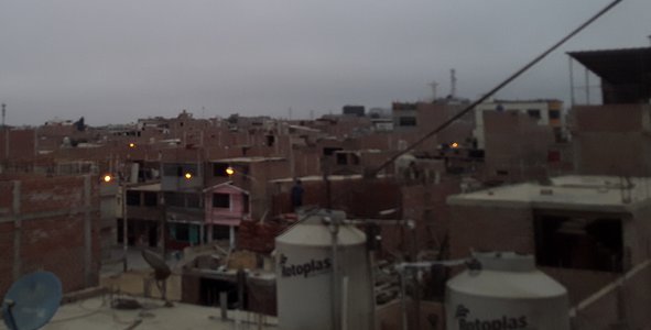
Through tools such as satellite images, drone images, cadastre maps, economy, amount of population, etc.to be able to indicate to the district municipalities the easy handling of it and thus be able to carry out a well-planned urban development plan, in the same way we will share a simple manual with the software and satellite images obtained from the platforms. With this, municipalities will be able to update their cadastre, this will optimize urban management, disaster risk management and tax collection. Likewise, identify the evolution of buildings, detect undeclared constructions, also illegal urbanizations and invasions of non-urban land.From this you can collect fairly the property tax which is the main source of municipalfinancing. And through these charges you can finance public works and invest in urban infrastructure, waste collection. Thus improving the quality of life of the neighbors. Proof of this is that the districts with the best urban cadastre system are San Isidro and Miraflores in LIma. Apart from this, it allows to guide more efficiently the investment in: water networks, drainage, electricity, communication, gas, public transport equipment of safety, health and sport.With this digital cadastre platform, adequate training for officials and awareness to the population for the payment of land we can take advantage of the opportunity to build sustainable, inclusive, healthy and safe urban cities in the name of the development of all Peruvians
Space Agency Data
SPACE APPLICATION LOGOS WERE USED FOR A BETTER PRESENTATION, THE AMAZE PROGRAM WAS ALSO USED FOR THE ELABORATION OF SLIDES.
Hackathon Journey
WE TAKE THIS EXPERIENCE WITH A LOT OF RESPONSIBILITY AND JOY, WE ARE NEW TO THIS NASA CONTESTS BUT THAT LEADS US TO BE PRESEVERANTES AND TO BE ABLE TO ACHIEVE A LOT OF EXPERIENCE. WHAT LED ME AND MY TEAM TO CARRY OUT THIS PROJECT IS THAT TODAY THERE IS A GREAT ECONOMIC DESTABILITY IN THE MUNICIPALITIES, IN THE URBAN, RURAL AREA, EITHER DUE TO CADASTRAL DISORDER AND INVATIONS THAT ONLY CAUSE DAMAGE TO THE ENVIRONMENT AND CHAOS IN THE CROWD. WE WORKED REMOTELY, EACH ONE FROM HIS WORK CENTER, BUT WE GAVE OURSELVES TIMES IN WHICH WE CAN DEVELOP THE PROJECT. I WOULD ONLY THANK MY TEAM FOR THE PERSEVRANCY AND THE MUNICIPALITIES FOR BEING SO MESSY THAT THANKS TO THIS IT GIVES US THE OPPORTUNITY TO PRESENT NEW PROPOSALS IN THE CADASTRAL FIELD
References
1. LINKOGRAFÍA:
Global Judging
This project has been submitted for consideration during the Judging process.