Awards & Nominations
TEDSA has received the following awards and nominations. Way to go!
Global Nominee

TEDSA has received the following awards and nominations. Way to go!
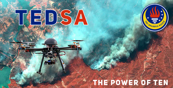
In many parts of the world, one of the biggest threats to the future of forests is undoubtedly wildfires.As TED Sakarya High School, we have developed this project to prevent wildfires from growing and to reduce their damage, using data from NASA. Since our national observation satellite GÖKTÜRK-2 can take a picture of the same place in 2.5 to 3 days, we aim to use UAVs with the purpose of observation.
TED SAKARYA HIGH SCHOOL
DRONE ROBOTIC TEAM

Over the last 20 years more than 400.000.000 hectars of land burned because of wildfires flying hotshots is aiming to prevent this disasterous activity from continuing. For a more sustainable natural life and ecosystem we aim to reduce the effects of wildfires
In the wildfires that occurred in our country this summer, we’ve seen that most fire extinguishing airplanes and helicopters aren’t able to fly at nighttime, which made it even more difficult to stop wildfires. Our innovative goal in this project is using interference drones that have the ability to fly autonomously at nighttime.
Our project is applicable because the technical infrustructure and serial comunication required for our project are accessible due to modern day technology
For Project Details Click.
For Project Video Click.
For Project Photos Click.
We have benefited from these world maps, which show the wildfires that urged on any given date.
Fire Map - NASA | LANCE | FIRMS
Thanks to these resources, we have examined the hazardaous effects of wildfires and according to the data we have gathered from wildfires/earthdata and EOSDIS Worldview we have determined a feasible and reliable sollution for wildfire prevention.
Land, Atmosphere Near real-time Capability for EOS (LANCE) Fire Information for Resource Management System (FIRMS) provides access to current and archived MODIS fire locations through an interactive web mapping interface, Web Fire Mapper.
This article shows how global warming catalyzes wildfires.
NASA Space Apps was an astonishing opportunity to develop solutions for global problems.
We had a chance to learn about the harmful effects of wildfires, technology that is actively used in fire extinguishing and the RTK Technology used for drone & UAV communication. We decided on this challenge due to the destructive effects of the wildfires that occurred in our country this summer. During our project, we understood the importance of organized and stable team work. We hope to make serious progress with our research and ideas in the name of protecting our forests and trees. We would like to thank our school principal Yelda Özel, our computer science teacher Furkan Gezer, and our Science teacher Vezir Kocabay
for their impacts to our project. We would also like to specially thank TED Çorum Schools due to their homeownership for this contest.
Never forget; The smallest ideas, can make the biggest difference.
#nasa, #spaceapps, #tua, #challenge, #tedsakaryakoleji, #wildfires, #uav, #drone, #dji, #ogm
This project has been submitted for consideration during the Judging process.