Awards & Nominations
Achiever's has received the following awards and nominations. Way to go!
Global Nominee

Achiever's has received the following awards and nominations. Way to go!
Risk updater this is a software that generates geographical data of user using the user's location. It is programmed to pre warn users. Using the topography of surrounding lands
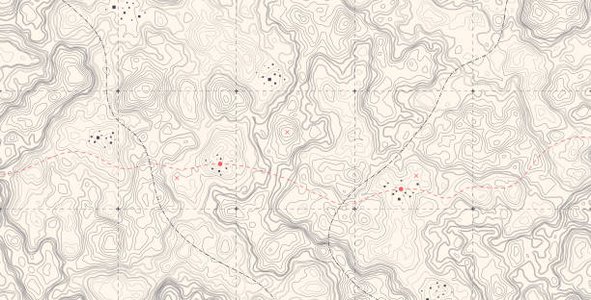
Risk Updater
Risk updater this is a software that generates geographical data of user using the user's location. It is programmed to pre warn users.Using the topography of surrounding lands,this could also be in form of a web page. It can also predict the whether.it is programmed to take statistics of conditions and give the average natural disaster after a period time.
It does this by reading the topography of the land using heatmapping to view vulnerable areas.
This app is meant to save lives of people living in rural areas prone to landslides by alerting whenever there is potential danger.
In recent years the surface heat of the earth has been increasing in a rather instatenous rate
We have taken steps to discussing the softwares capabilities.
https://gportal.jaxa.jp/gpr/notice/case/view/1015
https://www.eorc.jaxa.jp/water/map/index.html?area=global
#ideas #Nasa #Communities
This project has been submitted for consideration during the Judging process.
Landslides often interfere with the economic development of rural communities. Your challenge is to develop a tool that uses data from NASA satellites and ground-based sources to determine the risk of landslides in rural communities and share the results with local communities and governments.