
High-Level Project Summary
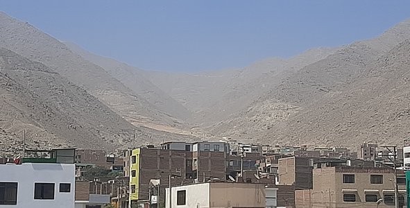
The purpose of this project is to create an application that helps people to make decisions in choosing a safe place for the construction of their home.This application is oriented to low-income migrant populations who decide to settle in a certain place, this application takes into account the risks of disasters that would be exposed as floods, landslides, avalanches, river overflows, recurrence of earthquakes, etc.Crossing data on the type of existing soil, accessibility facilities and the presence of existing equipment around that area.
Link to Project "Demo"
Link to Final Project
Detailed Project Description
This app will be able to provide you with information about the site you select on the map, such as access roads, hospitals, fire stations, geological and hydrological information; this way you will know if the space is suitable to live in. We hope that in this way we can warn and make more people aware of the space in which they live and thus be prepared for chaotic situations, although it is true that our target audience are the Peruvian communities that inhabit these spaces, it is expected that the application can be used anywhere in the world.
Software: Android Studio /Language: Java
Space Agency Data
All the data we use is detailed in the main pdf.
Hackathon Journey
-The passage through this challenge was enriching for our team, thanks to the conferences we have more knowledge about the topics covered and how NASA works.
-We chose the challenge ¨Identifying risk with science + communities¨ because it is a problem that our community goes through year after year due to landslides caused by the phenomenon of ¨El Niño¨ in the areas near where we live.
Because these spaces are occupied by low-income people who do not have much information about these areas, our goal is to provide the community with a tool through which they can have more information about the spaces they choose to reside and eventually curb the increase of overpopulation in these risk areas, because the spaces they choose to have their homes are not the most appropriate and end up being victims of these natural disasters, but in turn to serve as a warning of the possibility of a natural disaster for current residents.
This application is oriented to low-income migrant populations that decide to settle in a certain place.
-We have come together virtually through the meet platform to share ideas on what we are going to do.
References
We have been using information on websites:
-https://search.earthdata.nasa.gov/search/granules?p=C1711961296-LPCLOUD&g=G1726738147-LPCLOUD&sp[0]=-76.97144%2C-11.97003&tl=1633306814!3!!&fs10=Terrain%20Elevation&fsm0=Topography&fs20=Topographical%20Relief%20Maps&fst0=Land%20Surface&m=-11.865234375!-78.62255859375!7!1!0!0%2C2
-https://rpp.pe/economia/economia/inei-migracion-lima-cuantas-personas-se-mudan-a-lima-cada-ano-venezolanos-noticia-1221551
-https://technology.nasa.gov/
-https://neo.sci.gsfc.nasa.gov/
-https://developer.android.com/studio
Tags
#communities, #landslides, #solution, #ideas
Global Judging
This project has been submitted for consideration during the Judging process.