
High-Level Project Summary
The most crucial phases of a flight are taking off, reaching its destination safely, and landing. It’s in the hands of the captain and the first officer to do all these things perfectly and take us to our destination safely, but nature is always unpredictable. There are adverse weather conditions that can happen after taking off and can put thousands of lives in danger. Therefore, we have come up with a solution that helps pilots make decisions instantly and find the route that is optimal for their fuel capacity and can help them escape the bad weather and reach their destination with protection.
Link to Project "Demo"
Link to Final Project
Detailed Project Description
The most crucial phases of a flight are taking off, reaching its destination safely, and landing. It’s in the hands of the captain and the first officer to do all these things perfectly and take us to our destination safely, but nature is always unpredictable. There are adverse weather conditions that can happen after taking off and can put thousands of lives in danger. Therefore, we have come up with a solution that helps pilots make decisions instantly and find the route that is optimal for their fuel capacity and can help them escape the bad weather and reach their destination with protection. There is something called Air Traffic Flow and Capacity Management (ATFCM), which belongs to the Air Traffic Management (ATM). ATFCM will likely make airspace and air terminal limit satisfy traffic need and, whenever limit openings are depleted, advance traffic streams to meet the accessible proportions. Any aircraft that is in the air will be connected with one or the other ACT (Air traffic controller) throughout the journey, but if in an adverse weather condition if the connection is lost our model will help the pilot to have the situation under benchmark. Having that in mind, we planned to bring in automation in route prediction for flight. The way the aircraft is routed is a pattern and these pattern designs are called “rotations”. Network design is both a science and an art and machine learning (ML) can be applied to network design patterns. ML can analyse aircraft patterns and the commercial, financial and operational implications thereof. Five common patterns are found in airline networks, where each of these patterns follows a certain straightforward approach to calculate Commercial impact, operational impact, and Disruption cost. The proposed methodology helps ATC management and flight pilot to give pre-tactical traffic information in the form of graph visualizations, which will give information about pattern cost for every possible path along with weather updates. So, at any adverse condition(weather changes) the ATC can help the pilot choose the best pattern for the travel, or in the unfortunate case where the pilot lost the connection with ATC can make the decision himself with graph view and the most crucial phase of a flight is landing, the safe landing of an aircraft is in the hands of the captain and the first officer, there can be adverse weather conditions during which people in the cockpit may not be able to view the runway clearly or may not even locate it precisely. Therefore, we provide a model which helps locate the runway in bad weather conditions.
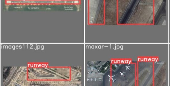
To make it automated we bring in ML and DL together to find out the best suitable algorithm which will represent the graph with distance information using graph neural networks and to calculate the overall impacts regression algorithms can be implemented. Once the path is decided and the aircraft is safely approaching its destination we use in machine learning algorithm YOLOv3 to detect the runway in bad weather, we provide satellite images of the destination and train the algorithm in such a way that it detects the runway in which the aircraft must land from a distance itself. It can be further extended to detect the lane, when the aircraft approaches the runway, for this, we first do the pre-processing of the video seen from the cockpit and use the video for edge detection using Kalman filter.
Thus the projectputs forward a new model which helps pilots predict the best possible routes from a point in the path to their destination in the absence of ATC, it also helps them trace out the runway when during bad weather. The model takes Wind Gust, Wind Speed, Humidity, Temperature, Pressure, fuel capacity as input and predicts the best routes possible. To trace the runway, the model uses the YOLOV5s algorithm and detects the runway in which the aircraft is supposed to land. The proposed methodology helps ATC management and flight pilot to give pre-tactical traffic information in the form of graph visualizations, which will give information about pattern cost for every possible path along with weather updates. The model is made to interpret the best pattern route considering commercial, operational, and financial capacity in pre tactic traffic plan. For future work, advanced solutions during take-offs, to ensure safe landings prediction of runway lanes using Kalman filter can be done
Space Agency Data
Airprots of USA:https://data.world/ourairports/989444cc-447b-4030-a866-57fcd6c2d3ee
Climate and weather data: https://www.climate.gov/maps-data
These are the data sets used to develop the webapp using ML
Got inspired since there were more accidents due to aircraft in the world due to many reasons,SO thought of decreasing that using technology,
Hackathon Journey
Amazing journey creating tonns of ideas and knowledge and understanding thought out the competition.
References
[1] Guo, X., Denman, S., Fookes, C., Mejias, L., & Sridharan, S. (2014). Automatic UAV Forced Landing Site Detection Using Machine Learning. 2014 International Conference on Digital Image Computing: Techniques and Applications (DICTA).
[2] Richards, R. A. (n.d.). Application of multiple artificial intelligence techniques for an aircraft carrier landing decision support tool. 2002 IEEE World Congress on Computational Intelligence. 2002 IEEE International Conference on Fuzzy Systems. FUZZ-IEEE’02. Proceedings (Cat. No.02CH37291).
[3] G. Yang et al., "Face Mask Recognition System with YOLOV5 Based on Image Recognition," 2020 IEEE 6th International Conference on Computer and Communications (ICCC), 2020, pp. 1398-1404, doi: 10.1109/ICCC51575.2020.9345042.
[4] Sriratanawilai, S., & Erjongmanee, S. (2018). Route prediction in air travel network using socio-economic factors and learning models. 2018 5th International Conference on Business and Industrial Research (ICBIR). doi:10.1109/icbir.2018.8391174
[5] Lee, Der-Hau & Liu, Jinn-Liang. (2021). End-to-End Deep Learning of Lane Detection and Path Prediction for Real-Time Autonomous Driving.
[6] Hellström, T. and Ringdahl, O. (2006) ‘Follow the Past: a path-tracking algorithm for autonomous vehicles’, Int. J. Vehicle Autonomous Systems, Vol. 4, Nos. 2-4,pp.216–224
[7] Parsa, Amir Bahador & Movahedi, Ali & Taghipour, Homa & Derrible, Sybil & Mohammadian, Abolfazl. (2019). Toward safer highways, application of XGBoost and SHAP for real-time accident detection and feature analysis. Accident; analysis and prevention. 136. 105405. 10.1016/j.aap.2019.105405.
[8] Xie, Z., & Zhong, Z. W. (2016). Aircraft Path Planning under Adverse Weather Conditions. MATEC Web of Conferences, 77, 15001.
[9] Marcos, Rodrigo & García-Cantú, Oliva & Herranz, Ricardo. (2018). A Machine Learning Approach to Air Traffic Route Choice Modelling.
[10] Aytekin, Ö., Zongur, U., & Halici, U. (2013). Texture-Based Airport Runway Detection. IEEE Geoscience and Remote Sensing Letters, 10(3), 471–475.
[11] Moore, A. J., Schubert, M., Dolph, C., & Woodell, G. (2016). Machine Vision Identification of Airport Runways with Visible and Infrared Videos. Journal of Aerospace Information Systems, 13(7), 266–277.
[12] Liu, C., Cheng, I., & Basu, A. (2018). Real-Time Runway Detection for Infrared Aerial Image Using Synthetic Vision and an ROI Based Level Set Method. Remote Sensing, 10(10), 1544.
[13] J. Clerk Maxwell, A Treatise on Electricity and Magnetism, 3rd ed., vol. 2. Oxford: Clarendon, 1892, pp.68–73.
[14] I. S. Jacobs and C. P. Bean, “Fine particles, thin films and exchange anisotropy,” in Magnetism, vol. III, G. T. Rado and H. Suhl, Eds. New York: Academic, 1963, pp. 271–350.
[15] K. Elissa, “Title of paper if known,” unpublished.
[16] R. Nicole, “Title of paper with only first word capitalized,” J. Name Stand. Abbrev., in press.
[17] Y. Yorozu, M. Hirano, K. Oka, and Y. Tagawa, “Electron spectroscopy studies on magneto-optical media and plastic substrate interface,” IEEE Transl. J. Magn. Japan, vol. 2, pp. 740–741, August 1987 [Digests 9th Annual Conf. Magnetics Japan, p. 301, 1982].
[18] M. Young, The Technical Writer’s Handbook. Mill Valley, CA: University Science, 1989.
Tags
#ML,#aircraft,#technology,#space,#weather,#climate,#air-traffic,#landing
Global Judging
This project has been submitted for consideration during the Judging process.