Awards & Nominations
AR Space Trash TrackAR has received the following awards and nominations. Way to go!
Global Nominee

AR Space Trash TrackAR has received the following awards and nominations. Way to go!
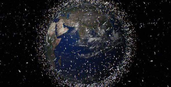
I decided to see if I could map the items orbiting the Earth in Augmented Reality for the Space Trash Tracking challenge.This solution shows how Augmented Reality could be used to visualise the orbiting items and does so in a more engaging way than traditional 2D screens.It is important as Augmented Reality will become more and more prevalent and become increasingly common and useful for a way of visualising and interacting with data.
The code was written in C#, and uses Xamarin to target Apples Augmented Reality framework (ARKit) and deploy to/ run on an iOS device. In this case my iPhone.
The first challenge I found was calculating the radius of the orbit as while height was shown in the Celestrak table, it was not included in the underlying data. I worked out how to determine the height of the orbiting item based on its rotations per day, the mass of the earth and the radius of the earth. Using the right ascension and radius to determine the position along its orbit was also tricky.
Once I had managed to plot the items and rotate them in their orbit I began adding additional functionality including..
Restrictions.
I used the Celestrak csv data of different orbital item types in csv format including
And could very easily extend my app to use all the other datasets available.
I learnt that orbiting has 1 t's and not 2! (After typing orbitting everywhere!)
I am very pleased with the way I managed to plot the items, them add additional functionality.
I had to dust off my trigonometry!
I am disappointed that I discovered that the way I was animating the orbits and their positions was incorrect and that to replace my method with using a satellite positioning package would mean completely changing my approach.. I had to make the hard decision to submit my current approach.
Whilst the orbits may be wrong, I think the concept is a useful, novel, engaging and innovative one.
I also struggle to find team members for these sorts of hackathons.. as
I miss read the submission instructions and initially created a 2 minute video demonstrating my app before creating the final 30 second version. I don't think 30 seconds is long enough for participants to describe their project. I struggled to describe it in 30 seconds.
Overall i'm very happy with what i've accomplished over such a short period.
#SpaceTrash, #AR, #AugmentedReality, #Mobile, #iOS, #XR, #MixedReality, #Innovation, #App
This project has been submitted for consideration during the Judging process.
The increasing amount of debris orbiting Earth could potentially limit our access to space, impacting not only exploration efforts, but routine aspects of our life on Earth. Your challenge is to develop an open-source geospatial application that displays and locates every known debris object orbiting Earth in real time.