Awards & Nominations
Space Collector has received the following awards and nominations. Way to go!
Global Nominee

Space Collector has received the following awards and nominations. Way to go!
Trash Tracker App is an app that allows the user to visualize in 3D, the orbits of Space Debris orbiting near their location in an specific moment in time, also displaying information about its history, in order to make access to Space Debris data easier, while raising awareness about a problem that sometimes remains invisible and causing a positive impact in society.For our project we implemented Orbit Predictor (a Python library that propagates orbits of Earth-orbiting objects using TLE, based on the implementation of. We analyzed a set of Space Debris and extracted the .tle files from Celestrak, which resulted in data such as: lalitude, longitude, height, position, speed and error.
We made a 4 minutes video explainig our solution, you can see it here (Spanish whit englis subtitles).
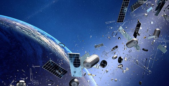
The information available regarding Space Debris is quite extensive and is available to everyone on the web. This is why our solution consists of an app, which collects public data and offers a more comfortable way to view it.
However, the problem of lack of wareness also arises and is linked to the fact that, for the general public, it is difficult to measure the amount of existing garbage. In addition to this, it is also perceived as something distant when it comes to space, and as it is not perceptible to the naked eye. Our proposal (Trash Tracker App) responds to this additional problem, allowing a better perception of the existing space debris, its location and its history. Interactively, it enables access to information in a more entertaining way, being suitable for the general public, and especially attractive to generate awareness among children and adolescents.
We are Space Collector, a multidisciplinary group of students and professionals gathered with the shared goal of expanding access to research and spatial information for the community in general.

A two-line element set (TLE) is a data format encoding a list of orbital elements of an Earth-orbiting object for a given point in time, the epoch. Using a suitable prediction formula, the state (position and velocity) at any point in the past or future can be estimated to some accuracy.
The TLE data representation is specific to the simplified perturbations models (SGP, SGP4, SDP4, SGP8 and SDP8), so any algorithm using a TLE as a data source must implement one of the SGP models to correctly compute the state at a time of interest.
The TLE format is a de facto standard for distribution of an Earth-orbiting object's orbital elements.
We use Orbit Predictor: is a Python library to propagate orbits of Earth-orbiting objects (satellites, ISS, FENGYUN-1C, etc) using TLE (Two-Line Elements set), based on the SGP4 implementation.
The following spatial tests were analyzed: FENGYUN-1C, COSMOS-970, RUBIN-8 & PSLV R / B, RUBIN-4 & SL-8 R / B, MICROSAT-R DEB and ISS. The input .tle files were pulled from Celestrak.
And as a result, we can determine for a given instant of time t:
All the results were applied to our country Argentina (ARG).
Just download the reposiory in GITHUB and run our main.ipynb.
We got the data of the positions from diferent derbis in diferent times, the values are here
When does sat on ARG happen again?
For the date analyzed: 10/02/2021 - Time: 00 hs: 00 min
Did this satellite pass through ARG at that moment? False
When does the sat happen again on ARG?
For the date analyzed: 10/02/2021 - Time: 00 hs: 00 min
Did this satellite pass through ARG at that moment? False
When does the sat happen again on ARG?
For the date analyzed: 10/02/2021 - Time: 00 hrs: 00 min
Did this satellite pass through ARG at that moment? False
When does the sat happen again on ARG?
For the date analyzed: 10/02/2021 - Time: 00 hrs: 00 min
Did this satellite pass through ARG at that moment? False
When does the sat happen again on ARG?
For the date analyzed: 10/02/2021 - Time: 00 hs: 00 min
Did this satellite pass through ARG at that moment? True
When does sat on ARG happen again?
For the date analyzed: 10/02/2021 - Time: 00 hs: 00 min
Did this satellite pass through ARG at that moment? False
We use WorldWind: is an open source virtual globe API. WorldWind allows developers to quickly and easily create interactive visualizations of 3D globe, map and geographical information.
Because WorldWind is completely open source, extending the API is simple and easy to do.
If you do not already have a web server, you can use a minimal development web server built in Node.js:
- Download and install Node:
Open a command line console in the root folder of your web app (where the ‘index.html’ file and your ‘./images’ folder is located).
In the command line console, run npm install http-server.
Execute the command http-server to start the server.
In your web browsear, head to the address http://localhost/:8080.
Another option is to use Python’s http.server:
- Download and install Python version 3.X.
Open a command line console in the root folder of your web app (where the ‘index.html’ file and your ‘./images’ folder is located).
In the command line console, run python -m http.server.
In your web browser, head to the address http://localhost/:8000.
More info about: How to get started?


Interactive Demo : http://www.retsagames.com/Friends/SpaceCollector/index.html
Documentation (Spanish): https://drive.google.com/file/d/16od3vUTk7jGMQCivcCJN89kMypHHw62u/view?usp=sharing
Other Docs: https://drive.google.com/drive/folders/17ruHt0WPSf0zCRYN7jmqpbt52IEz-kNX?usp=sharing
We get our data from NORAD (North American Aerospace Defense Command) via Celestrack (https://celestrak.com/).
We are from diferents provinces and know each other from diferent Space Hackatons . When we started some of us had problems, like Micaela that was in a Bus that crashed, or others partners that had to work in thats squedule. We didn't know in which location inscribe because we are from diferents locations, so we ended in a neutral location, the beautiful Chubut.
At first we didnt know if take the "seeds will travel" or the "space derbis" challenge, we ended taking the last one because no one knows about botanics. Taking the first one was really a challenge because we didn´t know much of space tracking either. Special thaks to Andres Miguel Airabella who give us an EXCELENT explanation of satelite tracking.
Each team member performed a different task, which helped us to reach a goal faster and in an organized way. Carlos made the havy dutty, the backend, in phyton (The beautifull code is in the description), Ignacio and Barbara made the visual part, in javascript (Also link in description ;D ), Sheila made the monograph, Denis made the videos and the speach, and Micaela made the mockup of the App.
At first we didnt had a proyect name so we said that is was called Space Collector , the team name, but then we change to Trash Tracker App but we couldn't modify all the places were the name was space Collector (Sorry for that).
The experience has been GREAT, AMAZING, BEAUTIFUL, LIFE CHANGING, ESPECTACULAR (we dont know the perfect word to describe it).
#trash #orbit #space #enviorment #worldwind #spacetrash #derbis #app #webApp #3D #3Dvisualization #phyton #javascript #html #css
This project has been submitted for consideration during the Judging process.