Awards & Nominations
Ice Exped has received the following awards and nominations. Way to go!
Global Nominee

Ice Exped has received the following awards and nominations. Way to go!
The Himalayas constitutes the second-highest number of glaciers after the polar regions. As the climate is warming up, the glaciers are retreating, resulting in the formation of pro-glacial lakes. Some of these glacial lakes may lead to glacial lake outburst floods. The region has already experienced such events in the past. The remotest villages in the region are the front liners, and most vulnerable and exposed to such events. As such glacial lakes are located in areas that are not accessible on the ground, here comes the role of space technology. This project aims to identify such hazardous lakes, which will help take necessary steps and precautions before any disaster takes place.
Our project focuses on identifying potentially dangerous glacial lakes which might lead to glacial lake outburst floods based on lake volume and peak discharge, estimated using mathematical models. It is a case study of the Drang Drung glacier, the second largest glacier in India, after Siachen Glacier. Automated mapping was also performed on GEE for extensive mapping using SAR data. Continuous monitoring of such lakes will alert concerned authorities, and help them make timely decisions, which will save numerous lives and reduce risk and damage to properties.
The challenge "Space for Change" aims to identify the marginalized communities and regions that are impacted by environmental hazards. This project aims to address the problem. The region of interest i.e., the Himalayan region is exposed to many such natural disasters. One of them being GLOF. Such events cause havoc damage to properties and lives.
As the glaciers are located in some of the inaccessible areas, here comes the role of space technology and satellite imageries. Many pieces of research have been done to study and identify such potentially hazardous glacial lakes, but not have been implemented in the practical mitigation process. Lack of early warning systems and implementation of existing researches have failed to mitigate and prevent such disasters. But, we believe 'a stitch in time saves nine.'
In this project, we used multispectral Landsat satellite images to show how to identify glacial lakes and calculate their approximate volume and peak discharge using a mathematical model proposed by Huggel et al. Further, using the peak discharge data, we grade the lake as hazardous or non-hazardous. We have also formulated a code for automated mapping of glacial lakes using Sentinel 1 SAR images by ESA, for extensive area mapping and monitoring. Temperature data and precipitation data were also considered, as they are some of the driving forces.
Drang Drung glacier is considered the second largest glacier in the region, after the Siachen Glacier. It is a famous tourist spot in the Ladakh region in India. Due to climate change, as most of the glaciers are retreating and losing their mass, similarly it is with Drang Drung.

Image source: TourmyIndia
Drang Drung is a huge glacier, with a length of 23.3km. The mean elevation is 5260m above sea level. Stod River originates from the meltwater of the glacier and is a tributary of the Zanskar River. There are many hamlets downstream of the river.
This project uses a simple yet profound workflow.
The following diagram shows the flowchart of the processes used

V = 0.104A1.42 where V: Volume of the lake; A is the area of the lake
Qmax = 0.00077V1.017 where Qmax: Peak discharge in cubic meter/sec; V: Volume of the lake
On Google Earth Engine:
A code was formulated to identify and map the glacial lakes using Sentinel 1A SAR data so that automated mapping is possible and is applicable to a larger area for extensive research and study. Check it here on GEE.

From the satellite imagery of 2020, the areal extent of the lake was found to be 19.69ha, whereas in 2015 it was 6.54ha. The area of the lake has almost tripled in five years (both images were taken in the same month/season).
And the peak discharge came out to be 694 and 3,408cubic meters/second in 2015 and 2020 respectively. To give it a scale, the Chorabari lake outburst in the 2013 Kedarnath Disaster, the peak discharge was 783cubic meters/second, and this caused havoc damage to property and huge loss of lives.
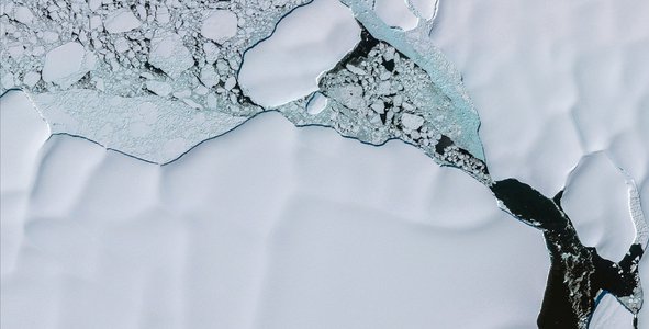
Glacier outline
DEM data with overlayed glacier outline and Glacial lake formation at the snout of the glacier
Climatic factors like temperature and precipitation were also considered to understand the dynamics of the area.
A hypothetical flood simulation model was generated using the DEM data, to understand the situation if there is a flood in the area. This simulation model has several shortcomings but it gives an idea about the inundation status, based on the elevation and topography. Check out the simulation here Flood simulation model
With this project, we hope to successfully implement it in the real world, with the help of local authorities or any NGO, so that we can help the communities that are the most vulnerable to such disasters. We also think of developing a web-based application, that will automatically detect the glacial lakes for the queried location using machine learning algorithms and give an inventory with details of such lakes to the users. This dashboard will help the government have access to a large number of potential GLOF sites, where timely intervention and necessary mitigation measures will help in preventing the disaster from happening.
Tools/Coding language/hardware/Software used:
Challenges faced:
Space Apps has helped us grow our knowledge in multiple ways. We got to know about many fields of application of spatial data in today's world. During this pandemic situation all over the world, and e-learning has made us students away from our institutions for a long. But working on this project for Space Apps Challenge together as a team has helped us come closer and work unitedly.
As we are from India, and our country boasts of the longest chain of the mountain range- The Himalayas. But due to climate change and global warming, this fragile and vulnerable ecosystem is collapsing. Multiple disasters like cloudbursts, landslides, glacial lake outbursts floods, avalanches, etc, takes place every year. We educate ourselves so that we could be of any help to the society we live. We then thought let us focus on GLOF events and develop a model by which we can have an early warning system and implement it practically on the field. We went through multiple pieces of research and studies, but the only thing missing was the integration of different researches, which made the difference! and thus, we tried to integrate them and developed this project.
Approach to developing this project
we first identified the issues that our communities face. Then we focused on a region. We then went through different pieces of research and studies and tried to find the gap. Here, the project focuses on a single glacier and its glacial lake to make the model and its workflow understandable. Various datasets and tools were then gathered to process the data and generate the desired output.
#Naturaldisaster #Glacier #GLOF #ClimateChange #DisasterManagement #RemoteSensing #SAR
This project has been submitted for consideration during the Judging process.


