
High-Level Project Summary
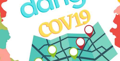
DENGCOV19 website informs users of the risks of COVID-19, which is specific to each city. In other words, the user can follow the levels of risk and susceptibility to the area being exposed to the disease. What decisions should be taken (through the advice of the World Health Organization)For example, you should wear a mask in indoor public places etc., in addition to the environmental risks that appear in the areas such as fire or gas leakage etc. Maps can aid better perception, visualization and reply planning for decision-makers in an immediately changing environment. Location intelligence gives real-time insights into the pandemic's impact. map connect with ministries (below the details)
Link to Project "Demo"
Link to Final Project
Detailed Project Description
DENGCOV19 website informs users of the risks of COVID-19, which is specific to each city. In other words, the user can follow the levels of risk and susceptibility to the area being exposed to the disease. What decisions should be taken (through the advice of the World Health Organization) For example, you should wear a mask in indoor public places etc., in addition to the environmental risks that appear in the areas such as fire or gas leakage. Therefore, if the area, for instance, is not fully vaccinated, it is dangerous to come there as a visitor to this country because of no population immunity. The website is similar to Tawakkalna, which is the official application of Covid-19 in the Kingdom of Saudi Arabia to stop the spread of Covid-19. Therefore, in turn, it helped in limiting the spread of the Covid-19 virus in the Kingdom. Thus, people who have a condition or are taking medicines that fail their immune system may not be adequately defended even if they are completely vaccinated. They should proceed to respect their situation. Featured here is when you open the website and the area you will go to, it will shake that's mean to be careful in this region. Instantly if any of the people you met recently got tested positive for covid-19 so you can start quarantining As Soon As Possible. The website is essential because it is one of the significant shifts in terms of saving people's lives. We aim to save your mother, father, daughter, son, sister, brother, husband, wife ( YOUR FAMILY!) and much more of people you love from the earth. In the end, clarifying the health status of its users if they sign in with your government through coloured codes with the highest levels of security and privacy and this dependency on your country system. However, we use the data from your resource in the development stage.
To conclude, it has the benefit of the tourist and the citizen of what risk they have before too late. In future, we aim to expand the map we are looking forward with a specialist in Artificial intelligence, specialists in infectious, environmental diseases, and doctors etc., we want to cooperate with them in the future to expand the circle not only on Covid-19 but on the other diseases This helps us in the case of a doctor registering a new disease for any patient. We would like to say Diversity is very important. It is a tragedy of what happened before to The United States of America, China, India, and other countries.
about DENGCOV19:
. Maps can aid better
- perception
- visualization
- reply planning for decision-makers in an immediately changing environment.
. Location intelligence gives real-time insights into the pandemic's impact.
. dangcov19 helps organizations place the most helpful resources to remain driving ahead.
However, we are unique because the map connect with ministries for example:
trash management: by locating waste combustion sites, landfills, environmental waste treatment plants and other things
The idea here is when I open the map, the specific colour, for example, violet, shows that there is a party or event. When selecting this occasion, the information of the experience appears, who is responsible and under which ministry also weather, what is popular in this city, hotels, sports, gathering places (connected with the people participating in this event how many they are). At the moment, we are working on the website's interface and type smart (icons like WhatsApp) to make it easier for the user to navigate and collect data for each ministry, such as gas station places, train places, available swimming sea and Danger for sea, places for swimming pool, private resort places, track mobility of medical and municipal waste and many others.The map has a thermometer and a climatometer on its side this contribute the organisations to To note any change in climate change ( carbon capture) . as you know the governments around the world they concluded in last event of earth day that they want to not reach 1 point 5 of carbon capture and scientists they predicted if we reached 1 point five we cant turn back to our normal life and we will face dangers positions in our life in term of a climate changes.
Our goal when the idea gets supported from your side will give us a chance to fly with more ideas in terms to build the exact map in real-time with multi-team.
In the end, this is not limited to the things I mentioned here. There are many additions that we want to look forward to, and they serve NASA, which are the locations of the launching stations, and it shows the exact time of launch, information, and other things. It also helps us know the ozone layer's state, the condition of one of the Earth's layers when a missile is launched. We want to find quick solutions, and this is one of the solutions to the situation. We believe that NASA loves ideas and creators. We hope to be unique with you. We all love diversity, we are human, and this is our land. We are proud that we are on this earth and with our families, so let's protect it by our investment in this multi-functions map.
now we trying to develop web next in the future app.
Space Agency Data
In this project, multiple tools are used. The site has been designed in Php, HTML, CSS and JS to make the site appear beautiful and clear for any user where he can access information easily, and the site displays data related to the Covid 19 pandemic in the Kingdom of Saudi Arabia, where the details of the developments of the Covid pandemic appear. 19 in terms of the number of daily injuries and the number of daily deaths, as well as daily recovery cases, and then expectations for the coming days. ( we are in early stage).
we use data from:
- https://www.moh.gov.sa
- https://covid19.who.int
- https://eodashboard.org
- Coronavirus disease (COVID-19) - Current Situation (Web Site) - Government of Canada
earth observing dashboard :
- Economic Indicators
- Agriculture Indicators
- Air Indicators
- Water Indicators
- Health Indicators
- air quality
- covid data
- Greenhouse gases N2 EMISSION, GLOBAL CARBON MONDIXIDE ...
Color Legend:
- Better than baseline
- As baseline
- Worse than baseline
- Upcoming data
- Global data
WHO Coronavirus (COVID-19) Dashboard and their website also Kingdom of Saudi Arabia- Ministry of health portal from their data we extract the information of COVID-19 and other diseases and the decision of the government and user they have to take.
These resources also include the types of vaccines used in each region and the vaccinated and non-vaccinated in each area.
(still we are in early stage in develop process)
Hackathon Journey

The hackathon is a challenge, and this challenge benefited in terms of educational awareness in solving problems in a short period. This is our first participation here, and to be general in the hackathons journey, we have learned a lot. The community in space Saudi app is hugely diverse from researchers, designers, programmers, developers, analysis data, people interested in space, scriptwriters, and others. From this source, we can employ our respectable expertise to reach creative technical solutions or even ideas. This is very proud for us.
The challenge was for our team that we are two people with different scientific backgrounds. Honestly, It's complicated to balance things like time management with our regular lives, plus implementing the concept as one person working on the web is stressful. Therefore, thinking complex to get the ideas also it is challenging! Still, each of us has a particular interest since the time is short; we decided on the first of October to be a team and thinking quickly about something new, at least unique than others, because of the difficult time the site was initially developed. We knew The idea deserved to be worked on in reality if we had much more time, but why not? Hahaha.
We learned the team is not number at the moment; as long as we strive to achieve your reading, dear reader, we are delighted that this is our goal right now !!!
We Hope Nasa help us to Achieve a multifunction map. It is Such Innovative and Proudly to make like this ideas. Honestly, Due To Your Achievements, One Of The Most Historical 1926, Successfully Launched The First Liquid-Fueled Rocket, and there are more! Nasa, you are amazing; We Want To Achieve this map with you guys !!
Thank you, NASA. We love you with all our hearts. We enjoyed ourselves a lot With this battle with the creative teams. We hopefully, to get the chance with NASA team in order to continue together with this idea.
References
Tags
#covid19 #dangcov19 #website #early_stage #teamwork #team_work #NASA #environmentissue
Global Judging
This project has been submitted for consideration during the Judging process.