
High-Level Project Summary
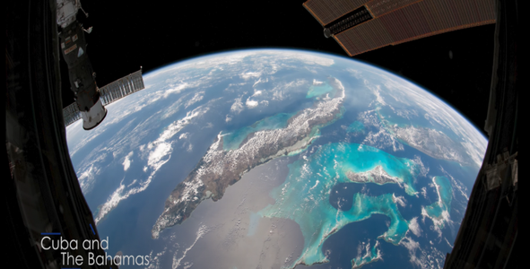
There is no doubt that what monitoring organizations do is of great importance, and without it, we would not have used to overcome many disasters or even find solutions to them. Monitoring, for sure the problems will be small after monitoring, knowing that these problems would happen to the whole world, whether individuals or countries.Earth monitoring is to collect information on physical systems, chemical and vital to the planet by using the remote sensing technology to the earth scanning techniques, including collection, analysis and data display.
Link to Project "Demo"
Link to Final Project
Detailed Project Description
Earth monitoring is to collect information on physical systems, chemical and vital to the planet by using the remote sensing technology to the earth scanning techniques, including collection, analysis and data display. Earth monitoring is used to monitor and evaluate a state, changes, natural environment and build. In recent years, the monitoring of the land has become more developing technological, and it is also important as the tragic impact of contemporary human civilization on the planet, as well as to redeem this as negative effects as well as access to land earth leaders to promote social and economic well-being.
Earth observations include:
*Digital measurements taken with a thermometer, an anemometer, an altimeter, or a seismometer.
* Images, radar or sonar captured from land or devices on the ocean floor.
* Decision support tools based on processed information, such as maps and models.
Some of the devices used in Earth observation:
* Satellite TIROS
The first image of Earth was observed by this moon.
* In 1450, Leon Banista Albert developed the oscillating plate to measure the anemometers and was the first anemometer.
* In 1607, Galileo invented the thermoscope
* In 1662, Asser Christopher Wren invented the self-discharge mechanical rain gauge.
* In 1643 Evangelista Torricelli invented the mercury barometer.
Some Earth Observation Areas
Southwest USA.
Hawaii, Canary Islands, Andes Mountains, High Mountains.
Sierra and Migra in Mexico.
The Mauna Kea Observatory, an observatory located in a mountain in the central part of East Antarctica, is one of the best.
Radio observatories in the valley
Palomar Observatory.
The World Meteorological Organization said: some parts of the monitoring system had already been affected. Most notably, the significant decrease in air traffic, which had a clear impact. In-flight measurements of ambient temperature, wind speed and direction are a very important source of information for both weather forecasting and climate monitoring.
Meteorological data from aircraft
Commercial aircraft contribute to the Aircraft Meteorological Data Relay System, which uses onboard sensors, computers and communications systems to collect, process, coordinate, and transmit meteorological observations to ground stations via satellite or radio links.
In some parts of the world, especially in Europe, the organization said that the decline in the number of measurements over the past two weeks has been dramatic, noting that countries affiliated with EUMETNET, a collaboration between 31 national weather services in Europe, are currently discussing ways to enhance the short-term capabilities of other parts of the world. its monitoring networks in order to partially mitigate the loss of aircraft monitoring operations.
According to WMO, the traditional aircraft meteorological data retransmission system has produced more than 700,000 high-quality daily observations of air temperature, wind speed and direction, along with the required positional and temporal information, and with an increasing number of humidity and turbulence measurements being made. .
Surface weather observations
Although in most developed countries surface weather observations are almost completely automated, in many developing countries the transition to automated monitoring is still in progress, and the meteorological community still relies on observations made by weather observers manually and transmitted to International networks for use in global weather and climate models.
Astronomers have photographed a large asteroid rapidly approaching the planet, which the American "NASA" agency described as a potential danger.
The asteroid, which bears the symbol (1998 OR2), is traveling very quickly on a very close path to the planet on April 29.
According to estimates, the asteroid, described by NASA as a potential danger, will approach the planet, about 6.29 million kilometers away, according to "World Today".
Astrophysicist Gianluca Massi, head of the Virtual Telescope Project, said that it is likely that the asteroid will be bright enough on the night of its approach to Earth, to be seen with sufficient accuracy, and we will be able to view it through ordinary telescopes and binoculars.
The Chinese space agency said the debris of its out-of-control space rocket that was heading toward Earth fell into the Indian Ocean.
The bulk of the missile crashed while re-entering the Earth's atmosphere, but local media said that the wreckage fell Sunday west of the Maldives.
American and European monitoring sites have been anxiously tracking the trajectory of the huge "Long March 5B" missile that China launched late last month, carrying a unit from a Chinese space station under construction.
US officials and others have warned of the risks of damage from the missile strike.
But the Chinese authorities have played down the potential risks.
Space Agency Data
- وكالة ناسا (NASA) هي وكالة حكومية أمريكية مستقلة تأسست عام 1958م لبحث، وتطوير المركبات الفضائية، والقيام بأنشطة استكشاف الفضاء داخل، وخارج الغلاف الجوي للأرض، وكلمة ناسا هي اختصار للإدارة الوطنية للملاحة الجوية والفضاء (بالإنجليزية: National Aeronautics and Space Administration)، والتي تأسست كرد فعل على إطلاق الاتحاد السوفييتي لسبوتنيك (Sputnik) عام 1957م، حيث نُظمت الوكالة حول اللجنة الاستشارية الوطنية للملاحة الجوية (NACA)، والتي قام الكونغرس بإنشائها عام 1915.[١] بقيت وكالة ناسا خلال سنوات تأسيسها الأولى تحت إدارة حكومة الرئيس جون ف. كينيدي، والذي اقترح أن ترسل الولايات المتحدة إنساناً إلى سطح القمر بحلول نهاية الستينات، ولهذا صُمّم برنامج أبولو، ليُصبح رائد الفضاء الأمريكي نيل أرمسترونغ أول رجل هبط على سطح القمر.[١] أهم إنجازات ناسا بدأت ناسا أعمالها في وضع برامج لرحلات فضائية بشرية، وقد ساعدت البرامج المختلفة مثل مشروع أبولو (Apollo)، ومشروع (Mercury)، ومشروع جمناي (Gemini) ناسا في فهم كيفية الطيران في الفضاء، والتي نتج عنها هبوط أول بشري على سطح القمر، وذلك في عام 1969م، كما زارت المسابير الفضائية الروبوتية التابعة لوكالة ناسا كل كوكب في النظام الشمسي والعديد من الأجرام السماوية الأخرى، بالإضافة إلى أنّ التلسكوبات الخاصة بها قد مكنّت العلماء من استكشاف مناطق بعيدة في الكون.[٢] وفرت الأقمار الصناعية كميات هائلة من البيانات حول الأرض، والتي أدت إلى التوصل لمعلومات مهمّة، ومفيدة للإنسان مثل الفهم الأفضل لأنماط الطقس، ويذكر أنّ وكالة ناسا قد ساعدت على تطوير واختبار مجموعة متنوعة من الطائرات المتطورة، كما ساعدت اختبارات وكالة ناسا المهندسين على تحسين النقل الجوي، وساهمت تقنياتها في العديد من الأنشطة المستخدمة في الحياة اليومية، مثل أجهزة الكشف عن الدخان، وحتى في الاختبارات الطبية.[٢] الهيكل التنظيمي لناسا تغير الهيكل التنظيمي لوكالة ناسا على مدى عقود، وذلك للوصول إلى أكبر كفاءة ممكنة، والتأقلم مع التغيرات في أولوياتها بعد مشروع أبولو، وتقع مديريات البعثات التابعة لناسا في واشنطن، كما تمتلك ناسا أربعة مكاتب رئيسية تعمل من خلالها على تحقيق أهدافها، وهي كما يأتي:[٣] مكتب أبحاث علوم الطيران: يختص هذا القسم بالبحث والتطوير لتوفير مركبات طيران، وأنظمة طيران آمنة، وموثوقة. مكتب أنظمة الاستكشاف: تساعد هذه الأنظمة على تطوير تقنيات لدعم استكشاف الإنسان والروبوتات للفضاء. مكتب العلوم: يختص عمل هذا المكتب باستكشاف الأرض، والشمس، والنظام الشمسي، والكون من خلال البعثات التي يقترحها علماء ناسا في كل من وكالة وأكاديمية ناسا. مكتب العمليات الفضائية: يدير هذا المكتب عمليات إطلاق المركبات الفضائية، وعمليات التشغيل، والاتصالات لجميع المركبات الفضائية في مدار الأرض، وخارجه.
Hackathon Journey
- قمنا بالبحث عن معلومات ومشاريع سابقة للتحدي وتناقشنا مع بعض وكانت رحلة لطيفة مليئة بالخبرات العظيمة
References
*Sources and references
-Google Scholar.
- Articles from Nasa Space Apps.
-New Scientist.
-Some books about space.
-Articles from the world Meteorological Organization.
-JAMA.

Tags
We used some beautiful designs in our research and they are very good.
Global Judging
This project has been submitted for consideration during the Judging process.