Awards & Nominations
D.U.Q. Method has received the following awards and nominations. Way to go!


D.U.Q. Method has received the following awards and nominations. Way to go!
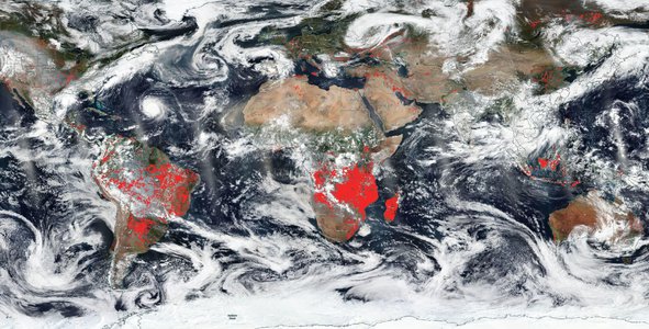
Year after year thousands of acres are burned and families are displaced due to wildfires.What else can be done so that fewer people, flora, and fauna are affected by them? Here appears the Method D.U.Q, an analysis system to help decision-makers and to measure the impact of decisions on forest fires.It consists of analyzing the current forest fire, whose information comes from satellite images, comparing it with a hIstorical database of similar fires, and providing coefficients that quantify the benefits of using satellite data.This tool will change the way of seeing the impact of the decisions to be made in the event of a forest fire and will allow us to be better prepared each time..
On the basis that the challenge is to describe how Earth-observations inform a specific decision that leads to better results for society, in terms of tangible benefits, and to propose a strategy to measure these benefits. We have decided to evaluate and develop two main aspects, one oriented to detail how through documentation, records, and existing satellite information decisions have been made and actions planned for the benefit of society, and the other related to how decision-makers and organizations can use these satellite data, which are currently available including those that will be on upcoming missions, to create strategies that lead to better outcomes for society and the environment in which we live.
Nowadays, it is known that fires are a cause of global concern since they generate large losses of biodiversity, and it is also known that poor management of a fire, in addition to the disaster it causes, brings with it a series of consequences. Therefore and in relation to the United Nations Organization and its focus on 2030, we will focus on number 15 of the Sustainable Development Goals, Life on Land, where Earth Observation Systems [EOS] achieve a unique impact within the forestry sector. As shown in the table below from the European Space Agency [ESA], where it is shown that one of the important applications of EOS is in reducing the risk of fires, from their detection to how to respond to these emergencies.
Once this field of application of the EOS has been visualized, we will proceed to develop the challenge focused on this major global concern.
Based on a search conducted in Space for Us for more information, we have decided to focus on the mapping system developed by Keith Weber being a joint project of NASA’s Goddard Space Flight Center [GSFC], the Bureau of Land Management [BLM] and the Idaho State University called RECOVER [Rehabilitation Capability Convergence for Ecosystem Recovery] focused on providing cost-effective and cutting-edge GIS analytical capabilities to agencies in the fighting wildfires, which through the use of existing satellite data allows:
One evidence of this function is what happened in Idaho, an area with regular episodes of drought and wildfires, were ignited by lightning on August 10, 2015, the Soda Fire, feeding on shrub-steppes, burned rapidly to cover 120,000 acres. (486 square kilometers) on the afternoon of August 12, is described as "One of those fast-moving megafires that can be very troublesome.". Then, faced with the immediate need for the Bureau of Land Management [BLM] to access real-time data on the extent of the fire and recent impacts, the use of the RECOVER system allowed it to quickly assess the fire damage and identify areas for rapid treatment. and restoration.
Regarding the use of this tool, Katherin Rowden, a hydrologist at the National Weather Service Office, clarifies that just having a fire intensity product is crucial for her post-fire work, being thus possible to have an idea of where the real trouble spots could be.
Thus achieving in supporting those who make decisions so that they could make good decisions on how to fight the fire and subsequently manage the land after the fire.
An example of the need and importance of this function is what happened in the Okanogan Complex in Washington, whether in 2015 when over 300,000 acres of land were burned and 3 firefighters died, as in subsequent years where wildfires continued to spread across the landscape. Pre Concern then arose, as described by Katherine Rowden: "Due to the risk of flash floods that persists after a fire, it is necessary to have an estimate of how the fire affected the landscape."
This is where the Online Mapping System RECOVER is used, which automatically integrates a multitude of data and images from remote satellite sensors to produce near real-time updates of the effect of a wildfire on the ground.
NASA's RECOVER Wildfire Decision Support System (DSS) creates a single tool that automatically integrates 26 layers and sets of data and images, including current and archived satellite-terrestrial and infrared image data specifically designed for each fire event being analyzed [Table 1] in approximately 5 minutes. That is, it gathers and overlays image information of burned and burning areas to produce real-time updates in an easy-to-use interface, accessible in a Web browser, thus providing data to also identify the areas that need reseeding or other post-fire treatments. These standard base layers are acquired from authoritative sources, regularly updated using Esri's ArcGIS software, and as part of RECOVER's value-added suite of capabilities, these base layers can be enhanced upon request by adding other fire-specific layers, NDVI anomalies/outflows, and debris flow probability.
In addition to the base layers that are kept up-to-date, there are other value-added enhancements, which are stored on an ISU GIS TReC server and are instantly accessible through RECOVER have the potential to save many hours of a land manager's time while researching the fire site.
Thus, end-users who make their decisions are provided with the following tools:
Drawing the analogy of two worlds, in which one in which satellite information is available, such as RECOVER and the Landsat satellite, and is used by decision-makers, we find that this system by gathering up to 26 different data sets, including wildlife habitat and local topography, is a system that helps BLM rehabilitation teams to assess the situation more completely and quickly; that in contrast, in another world where satellite information is not available or isn’t used by decision-makers, remediation teams would have to wait for the fire to be contained and then complete an assessment before submitting a rehabilitation plan, which according to Gregory Mann, BLM fire ecologist, would include surveying multiple sites for information on soil layers, plant species composition, burn severity mapping, and other additional data.
Among the decisions that Keith Weber just suggests, can be facilitated through this technology and using the tools provided are those of:
It should be noted that in relation to the Washington application case, it is recognized that fire can also affect the chemistry of the soil, causing it to later repel water, allowing there to be a large difference in the amount of water leaving during a subsequent storm and a debris flow.
In order to analyze and develop this stage of the challenge, 3 possible scenarios will be proposed, one of which would be scenario 0 or base scenario, in which satellite data is not used. Scenario 1, such as the cases of Idaho and Washington, where satellite data was used through a system such as RECOVER for their strategies and plans. And scenario 3 in which the objective is to optimize the use of the satellite data systems that are used, is possible through Method D.U.Q. [Data Usage Quantification], an analysis system that provides concrete information to estimate the impact and follow up on decisions related to the prevention, remediation, and rehabilitation of soils after a forest fire. It also demonstrates through statistics the benefits linked to the welfare of the people involved in these phenomena as well as to the preservation of environmental resources.
In relation to the first two scenarios. The system’s use of one of its functions detailed above related to rapid remediation of fires supports the initial rapid assessment for post-fire rehabilitation, even when firefighters are still in the risk and action zone, thus preserving safety and security and integrity of fire personnel.
It also benefits decision-makers as the information gathering process was usually challenging and time-consuming, often taking more than a week to complete. Thus allowing, as it was in the Idaho wildfire, rehabilitation teams to already have a customized analysis complete and ready to use during the Soda Fire. As Karen Miranda, a member of the Emergency Stabilization and Rehabilitation team, says: ``Pre-planning before the fire is fully contained helps our work move forward as quickly as possible”.
Or as it was in Washington, where after analyzing the map provided by RECOVER, it could be detected that fortunately most of the houses were out of danger of catastrophic floods or risk of debris flow, being at a general level this tool necessary to make final risk assessments for later decision making, for example from the Washington State Department of Ecology.
Finally in relation to this particular situation in this state, Andrew Phay, from the Whatcom Conservation District, indicated that “Without [a single image resource], you would be spending time trying to get data from multiple agencies instead of working on post-fire reports and assisting team members”.
Finally for the development of the third scenario and the fundamentals of the Methodo D.U.Q. an analysis is performed to quantify the different effects of the fires, comparing the one to be analyzed with those fires with similar characteristics; understanding a similar fire as any fire where the measurable parameters by means of our satellite image observation system, for example, the RECOVER, are sufficiently similar to the fire in which we are working. Examples of these parameters are wind speed, humidity, fuel power (biomass), among others shown in the following table:
The different characteristics will be classified or will be part of 3 types of coefficients called D.U.Q coefficients:
Together they will allow us to quantitatively evaluate the progress that has been made based on the decisions taken previously and to project strategies for the future. After the mathematical model of the Methodo D.U.Q., each of the coefficients will be detailed.
The idea is that prior to the calculation of the coefficient it is necessary to::

Then, with the value obtained for the parameter, it must be determined whether it is detrimental that the new average is higher than the previous average, if this is the case, the sign of the value obtained should be changed
3. Finally, the software will make a weighted average of these relative differences, multiplying them by a constant of importance (f), which depends on the place, its characteristics, and the main objectives of the analysis. Obtaining, as a result, the Coefficient D.U.Q. searched by the following formula:

An example of the variation of the constants of importance is found in the case of the Effects Coefficient when we analyze a fire in a forest where the most important thing is the acres saved, the biodiversity preserved, while in a crop farm, although it is important how much the average temperature rose, it is not so important compared to the speed of mitigation and the number of acres burned.
It should be clarified that the mathematical model is rather a logical statistical model so that it can be adapted to different systems in addition to RECOVERY from which the source parameters were analyzed and detected to obtain the D.U.Q. coefficients.
The coefficients worked are given based on different parameters, these must be adjustable to the information that can be obtained at satellite level in conjunction with the available historical national and regional data. Due to these considerations, we will only describe some of the parameters that can be considered for this method.
Some of the parameters considered in the method that will be used in the last two stages [b and c] of the previously detailed process are detailed below.
Where we seek to quantify the number of deaths and missing persons due to fires. To do this, two characteristics must be known: The number of deaths attributed to fires [A2] and the number of missing persons attributed to fires [A3]; together they make up the parameter A1 [such that A1 = A2 + A3] that will enter the system database to be compared with the historical database and continue with the determination of the averages to obtain the relative difference Ar, necessary later for the weighted sum that will be done to obtain the coefficient.

Among the factors that can alter the indicator parameter A are deaths due to flooding, checking the relationship of the fire on soil absorption, and deaths due to runoff as a consequence of fires.
Unlike the previous parameter, the characteristics to take into account on this occasion are: The number of injured or sick due to disaster [B2], The number of people whose damaged homes are attributed to fires [B3], The number of people whose homes destroyed are attributed to fires [B4] and the number of people whose livelihoods were disrupted or destroyed by fires [B5]
Since the purpose of this parameter is to obtain in numbers the number of people affected by fires.
Proceed in the same way as the previous one when determining a parameter B1 [such that B1 = B2 + ... + B5] that will enter the system database to be compared with the historical database and continue with the determination of the averages to obtain the relative difference Br, necessary later for the weighted sum that will be done to obtain the coefficient.
Finally, once the parameters have been obtained, only the weighted average indicated by the mathematical method must be followed to finalize the calculation of the given coefficient, in this case, the Life.
As an example:

Where the fi's are the weightings that you want to take depending on the case
For the rest of the coefficients, the characteristics to be used will be explained, always based on repeating the mathematical method previously exemplified.
For example, for this coefficient within the parameters to take into account are the following:
For its calculation the NBR [Normalized Burn Ratio] characteristics are needed both before and after the fire; they establish an extension of the burned area comparing scenes to identify the extension and severity of the burn.
This parameter aims to quantify the acres that were burned, which as in the case of the Life coefficient, is compared with historical facts and the mean weights are determined.
For this particular parameter, the following characteristics or indicators are taken into account:
Direct agricultural loss attributed to fires [PE2]. Direct economic loss to all other productive assets damaged or destroyed attributed to fire [PE3]. Direct economic loss in the housing sector is attributed to fires [PE4]. Direct economic loss resulting from damaged or destroyed critical infrastructure attributed to fire [PE5]. Direct economic loss of damaged or destroyed cultural heritage attributed to fire [PE6].
Proceed in the same way as the previous one when determining a parameter PE1 [such that PE1 = PE2 + ... + PE6] that will enter the system database to be compared with the historical database and continue with the determination of the averages to obtain the relative difference PEr, necessary later for the weighted sum that will be done to obtain the coefficient.
Finally, once the parameters have been obtained, only the weighted average indicated by the mathematical method must be followed to finalize the calculation of the given coefficient, in this case, the Resources.
The purpose of this coefficient is to be able to quantify parameters that will allow us to evaluate the danger of a fire as well as to indicate if the evaluated measures allow preventing the fire in question. Its common parameters include:
It is made up of 5 different indices that indicate the dangerousness of the advance of a forest fire. The first 3 are numerical indicators of the humidity of dead fine fuels, the humidity of the first layers of the soil, and the humidity of the deeper layers derived from the cumulative effects of droughts on forest fuels, the last two are the speed expansion of the fire if the fuel is available for combustion and the intensity of the fire, that is, the amount of fuel available to burn; in effect, it links 2 indicators, the ISI and the BUI.
It has internally significant values starting with an FWI = 0, they are:
FWI <24, firehead control difficulty.
FWI <34, possibility of occurrence of extreme behavior.
FWI <50, conflagrations.
This parameter is based on measurements of the mitigation time of a specific type of fire based on the unit of surface analyzed [T / ac ^ 2]
This parameter is in charge of comparing the state of the soil before and after the fire. It is important since burned soils are chemically altered by high temperatures to form a hydrophobic layer. This leads to increased runoff and erosion.
One of the characteristics to take into account, which is identified from the RECOVER system, is called soil texture, it measures the amount of sand, mold, and clay that the soil contains.
Finally, once the parameters have been obtained, only the weighted average indicated by the mathematical method must be followed to finalize the calculation of the given coefficient, in this case, the Effects
Based on the work carried out, it was possible to rectify and demonstrate, beyond the fact that at first sight, the use of the data is beneficial, the great usefulness of the information provided by the different satellites and its great impact with regard to taking data. decisions, from facilitating them to allowing confidence in them. In this way, with this project report, it is hoped to be able to contribute in the visualization of these results and also, with the development of the DUQ method, it is really expected to generate that impact that will benefit society with this contribution in a significant way to the decision making.
Focusing more on the basis of the DUQ method, it is expected to be applicable to other computer systems in addition to RECOVER, in order to continue its development and implement in the near future a mathematical/statistical theoretical basis of greater strength, so that in addition to identifying risk areas in relation to forest fires and provide statistics that will serve for remediation and rehabilitation of soils, this method can achieve simulations of possible scenarios and thus advantageously influence more aspects such as economic aspects when making strategies in advance.
It was also possible to observe, throughout this project, how the collection and processing of information improved due to the use of satellite data, since before the processing for decision-making was very extensive.
Data from the NASA space agency was used extensively throughout the project. Among the most important uses are the files at:
https://appliedsciences.nasa.gov/join-mission/training/spanish/arset-observaciones-de-satelites-y-herramdamientos-para-el-risgo
Which provided us with information and an even greater understanding of how that operate the different NASA satellites are currently oriented to the prevention, mitigation, and measurement of post-fire effects.
This information allowed us to link the strategies that we had projected in a plan that can be carried out, providing us with resources such as the parameters that they determine, the scales they use for them, and the systems currently available that use them, such as the institutions that develop the RECOVER system.
All this information, together with that extracted from the databases of the Goddard Space Flight Center as well as those obtained from the National Commission of Space Activities of Argentina [CONAE], allowed us to create a method that manages to quantify the usefulness of the information provided by these satellites for different cases and an app to help the population make better decisions.
The experience was very pleasant and motivating since it is not every day that you have the opportunity to work on challenges as big as those posed in the hackathon. We have learned a lot about the use of tools that provide satellite data from NASA and other organizations, inspiring us to continue working with them in the future and incorporate them in future projects.
Regarding what inspired our team to take this challenge, we saw that lately there were many problems in our country regarding forest fires, and several of us were hit by cases such as the latest fires in Australia and Amazon. Based on this, we saw that this challenge gave us the opportunity to address these issues and try to do something to help solve it.
The approach to tackle the project was the exhaustive analysis of an existing case in order to get a good understanding of its importance for society and the consequences of not using it. We especially focused on fire prevention, mitigation, and consequence assessment and improving this based on the information provided, as well as working on ways to quantify the utility.
Our team dealt with the setbacks and challenges with all the motivation and commitment we could give, long discussions regarding various ideas, and long explanations for everyone to understand the various ideas were not lacking, but as a team, we feel that this managed to enrich the work greatly.
We would love to thank the regional organizers of the space apps for the information and guidance provided at all times, some even stayed up late to be available to answer our questions.
We must also thank the agency's specialists for the information provided to be able to work on the challenge because without this, we would never have been able to face it the way we did or learn so extensively the uses of the information provided by the satellites
#RECOVER #wildfire #Landsat #Fireman #Firefighter #FireSolution #space #earth #global #research #knowledge #data #information #nasa #nasaspaceapps
This project has been submitted for consideration during the Judging process.


