Awards & Nominations
Spectroscopy has received the following awards and nominations. Way to go!
Global Nominee

Spectroscopy has received the following awards and nominations. Way to go!
United Nations has highlighted land degradation as a major global issue and therefore outlined it as one of the sustainable development goals because combatting land degradation and achieving Land Degradation Neutrality are important for sustainable global future.
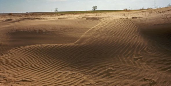
land degradation refers to reduction or loss of biological or economic productivity raised due to complexity in rain fed agriculture, irrigated agriculture, rangeland, pasture, forested land and woodlands resulting from combinations of natural and anthropogenic pressures in any ecosystem (Kiani-Harchegani and Sadeghi, 2020).some original references may be included like FAO Therefore several international organizations have highlighted Land degradation as one of the most serious environmental problems around the globe; because it is one of the major socio economic issues that seriously threats biodiversity and sustainable socio-economic development (Xie et al., 2020).Considering numerous disadvantages of Land degradation the concept of restoring degraded lands gained focus on International forums. Zero Net Land Degradation (ZNLD) was initially proposed at the United Nations Conference on Sustainable Development in the year 2012 to balance land degradation worldwide(UNCCD, 2016). General Assembly of the United Nations approved ZNLD as one of the Sustainable Development Goals (SDGs) specifically addressing Goal 15 among 17 distinct goals listed under SDG. To achieve ZNLD the concept of Land Degradation Neutrality (LDN) is very important because it identifies the amount and quantity of land resources necessary to support any ecosystem functioning so that it can ensure enhanced food security and services to remain stable or increase over time (Sims et al., 2020). Awareness programs on LDN increased research attention, therefore worldwide focus on the evaluation and monitoring of land surface based on different data sources became popular over time. According to Land degradation and Desertification report around 29.32% of total Indian land mass is undergoing constant threat (SAC, 2016) therefore immediate attention in the regional level needs to be fostered.Thus it is important to identify driving factors through trend simulation and quantitative modelling over regional landscapes to understand the dynamics of the processes active in the region(Yue et al., 2016).
Evolution of space technology has proved to be very promising in Land degradation analysis because it facilitates quick monitoring coupled with qualitative and quantitative results. The methods available in remote sensing for mapping and monitoring of desertification and land degradation at global, regional, and national scales can be broadly classified into two categories: (a) indicator‐based methods and (b) mapping of desertification processes and types (Christian et al., 2018). Among these indicator based methodology is popular because vectors influencing land degradation are easy to extract using remote sensing sensors and less time consuming than mapping processes which is usually time taking and qualitative decision making process.
Optical sensor based vegetation indices have been used as the best type of indicators to land degradation mapping across the globe (Mamy et al., 2011, Khaledian et al., 2017) but optical sensor have some disadvantages, like it cannot take observation during cloudy weather conditions or dust/haze events and in Northern India during the winter months many parts are affected by western disturbance which entails cloudy and foggy atmosphere…., which in case of Indian subcontinent is a major challenge because it lies in humid subtropical zone where cloud is a common phenomenon and dust events are also common disturbances in the north western part of India blocking extraction of information. Added to this optical datasets cannot penetrate in vegetation cover being governed by the surficial phenomenon of chlorophyll sensing and assess dry soil surface which are important measures for land degradation assessment. Microwave spectrum adds complimentary advantage in such situations because specially Synthetic Aperture Rader (SAR) helps to add information regarding scattering behaviour of any phenomenon on earth’s surface based on the dielectric properties of the soil, vegetation and geometric configuration of the scattering elements with respect to the wavelength, direction, and polarization of the incident wave (Rouse et al. 1973, Prevot et al. 1993). Also the higher penetration of C-band and higher wavelength renders it fit in all weather and also vegetation covered regions(references)Therefore this study focuses on synergic utilisation of Optical and SAR datasets to monitor land degraded land/desertification.
1. Objectives
(a) Computation of remote sensing based indexes like (Soil Adjusted Vegetation Index, Red Edge Normalised Vegetation Index, Normalised Green Red Vegetation Index, Radar Vegetation Index(RVI), Microwave Polarization Difference Index(MPDI), Soil Salinity Index, Normalised Differential Water Index, Normalised Differential Sand Index)
(b) Machine learning based modelling of the above indices to identify degraded land

Open source Datasets have been utilized for the study from European Space Agency Platform, multiple images of Sentinel-1 and Sentinel-2 have been used for reaching the goal . Machine learning based algorithms have been applied over the spectral signature trends of timeseries data sets for understanding land degradation processes active on arid lands were collecting field data is one of the biggest challenge.
This is great research forum to show or exchange thoughts. Its a journey to explore science, enthusiasm and compete with each other with true positive zeal. I would like to specially thanks ISTAR college of Gujarat for spreading the word of NASA challenge among different core regions in India. I believe this journey till the end will help us to grow and educate each of ourselves more and more on Earth Observation based complex challenges and ignite better plans to solve research issues.
Christian, B. A.,Dhinwa, P. S. and Ajai (2018). Long term monitoring and assessment of desertification processes using medium & high resolution satellite data. Applied geography, 97, 10-24.
Desertification and Land Degradation Atlas of India (Based on IRS AWiFS data of 2011-13 and 2003-05), Space Applications Centre, ISRO, Ahmedabad, India, 219 pages
Khaledian, Y., Kiani, F., Ebrahimi, S., Brevik, E. C., &Aitkenhead‐Peterson, J. (2017). Assessment and monitoring of soil degradation during land use change using multivariate analysis. Land Degradation & Development, 28(1), 128-141.
Kiani-Harchegani, M., &Sadeghi, S. H. (2020). Practicing land degradation neutrality (LDN) approach in the Shazand Watershed, Iran. Science of The Total Environment, 698, 134319.
Mamy, L., Vrignaud, P., Cheviron, N., Perreau, F., Belkacem, M., Brault, A., ...& Chaplain, V. (2011). No evidence for effect of soil compaction on the degradation and impact of isoproturon. Environmental Chemistry Letters, 9(1), 145-150.
Prevot L, Champion I, Guyott G. 1993. Estimating surface soil moisture and leaf area index of a wheatcanopy using a dual-frequency (C and X bands) scatterometer. Remote Sens Environ. 46(3):331–339
Rouse, J. W., Haas, R. H., Schell, J. A., &Deering, D. W. (1974). Monitoring vegetation systems in the Great Plains with ERTS. NASA special publication, 351(1974), 309.
Sims, N. C., Barger, N. N., Metternicht, G. I., & England, J. R. (2020). A land degradation interpretation matrix for reporting on UN SDG indicator 15.3. 1 and land degradation neutrality. Environmental Science & Policy, 114, 1-6.
UNCCD, 2016. Report of the Conference of the Parties on its 12th Session, Ankara, 12 to 23 October 2015. Part Two: Actions. ICCD/COP(12)/20/add.1. 3/COP.12, Page 8: Integra- tion of the Sustainable Development Goals and Targets into the Implementation of the United Nations Convention to Combat Desertification and the Intergovermental Working Group Report on Land Degradation Nutrality
Xie, H., Zhang, Y., Wu, Z., &Lv, T. (2020). A Bibliometric Analysis on Land Degradation: Current Status, Development, and Future Directions. Land, 9(1), 28.
Yue, Y., Li, M., Zhu, A. X., Ye, X., Mao, R., Wan, J., & Dong, J. (2016). Land Degradation Monitoring in the Ordos Plateau of China Using an Expert Knowledge and BP-ANN-Based Approach. Sustainability, 8(11), 1174.
#Land Degradation #Machine Learning #Earth Observation
This project has been submitted for consideration during the Judging process.