
High-Level Project Summary
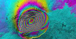
A SAR satellite transmits radio waves to map the terrain of the earth which is then used by scientists in mineral exploration, ice hazards, monitoring wildfires, to mapping floods, to understanding earthquakes.The radar also proved as an invaluable tool in World War 2 by identifying ships and planes in darkness through cloud cover and fog At the end of its three-year nominal mission, the NISAR satellite will have generated a larger data volume of products than all the data that is currently stored in NASA’s Earth Observing System Data and Information System (EOSDIS).This NISAR mission will also enable Nasa and ISRO to take measurements of ecosystem disturbances and natural hazards
Link to Project "Demo"
Link to Final Project
Detailed Project Description
The project explains what SAR is and also enhances the view of public on what SAR is and what it is used for.
We hope that the audience have understood what SAR is in simple words
We used canva.com for video editing and audio editing
Space Agency Data
https://earthdata.nasa.gov/learn/backgrounders/what-is-sar
Hackathon Journey
The experience was great, informative and enjoyable. We acquired knowledge of what a SAR is and the sole reason to choose the topic was because we wanted to understand what it is. The team coordinated very well and all the setbacks and challenges seemed nothing coz all of us had our own share of input in this project, so therefore we'd like to thank each other for showing such great synergy and we'd also like to thank the organizers for giving us a chance to instill such new knowledge