

High-Level Project Summary
In contrast to traditional radars that only work on taking pictures in cases of clear climate, I dealt with the project to clarify the definition and importance of the sar rader, and the definition represented that it is a radar capable of imaging the Earth with high accuracy in all climatic conditions, and its importance was to determine the soil moisture and natural disasters before its occurrence such as earthquakes and volcanoes, is a great move for the world in the near future
Link to Project "Demo"
Link to Final Project
Detailed Project Description
project is to create a 3 to 5 minute video for the public, and it is in fact a video that contains information and simplified data for the Sar technology and what are its data and its potential. Not only knowing that, but also it facilitate the scientific content about how the does SAR works. In addition of making the content interesting for all people in all ages. We make the video looks simple, we also aspire to make it very interesting to others as we never give scientific content to a normal technology like Sar technology, but the normal is to present the idea in a familiar way. What we also aspire to is that we give each content that presents the idea and the ideal and the appropriate presentation for it. i used power director for make the video
Space Agency Data
from Nasa earth data :
Also see: Synthetic Aperture Radar (SAR) and InSAR Guides.
How Does it Work?
A synthetic aperture radar (SAR) is an active sensor that first transmits microwave signals and then receives back the signals that are returned, or backscattered, from the Earth’s surface.
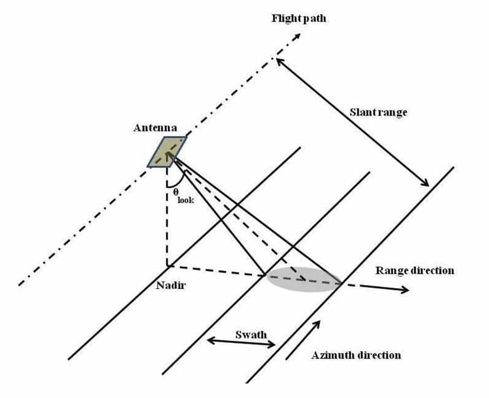
Flight and Directional Terminology
The instrument measures distances between the sensor and the point on the Earth’s surface where the signal is backscattered. This distance is slant range (see illustration), which can be projected on the ground representing the ground range. The flight direction is also referred to as along-track or azimuth direction, and the direction perpendicular to the flight path is the across-track or range direction. The angle between the direction the antenna is pointing and the nadir is the look angle. The angle between the radar beam center and the normal to the local topography is the incidence angle. Both angles are sometimes used synonymously, which is only valid if the In SAR geometry is simplified neglecting the Earth’s curvature and the local topography. Because the look angle of the sensor significantly affects the behavior of backscatter, it is one of the main parameters determining the viewing geometry and the incidence angle of the backscattered signal. Depending on the characteristics of the illuminated terrain, areas of layover and shadow may occur in the imagery.
Wavelength and Effects
The wavelength of the sensor determines the penetration depth of the transmitted signal into the vegetation layer of the terrain surface. The longer the wavelength, the deeper the penetration can be, particularly in forests.
- The energy of an X-band sensor is mainly returned at the top layer of the canopies
- Most of the L-band signal penetrates through the upper vegetation layer and is returned at the ground surface.
- The backscatter behavior of C-band is less predictable. Due to volume scattering effects, the layer of backscattering is less determined and does not correspond directly to a terrain surface — neither the vegetation surface nor the ground surface.
A typical side-looking radar pointing perpendicular to the flight direction. Credit: NASA.
Resolution and Speckle
The spatial resolution of the radar sensor defines the minimum separation between the measurements the sensor is able to discriminate and determines the amount of speckle introduced into the system. Speckle is a scattering phenomenon that arises because the spatial resolution of the sensor is not sufficient to resolve individual scatterers. Speckle can be reproduced if the acquisition conditions are identical, while noise is random in nature. Speckle is removed by multi-looking. The higher the spatial resolution of the sensor, the more objects on the ground can be discriminated. The term spatial resolution is often confused with the pixel size, which is the spacing of the pixels in the azimuth and ground range direction after processing the data.
Hackathon Journey
It was a journey full of research and knowledge, discovering everything new and making use of the time as much as possible. I will certainly love to repeat this experience again to increase my information more and more, but next time with my team who is passionate about space with more simplicity in providing content to everyone because learning is for everyone
References
1-https://earthdata.nasa.gov/learn/backgrounders/what-is-sar
2-https://www.youtube.com/watch?v=em41MxplcDc
3-https://l.facebook.com/l.php?u=https%3A%2F%2Fasf.alaska.edu%2Finformation%2Fsar-information%2Fwhat-is-sar%2F%3Ffbclid%3DIwAR0BdIoTBejdXJ61Jr59KzZfzxBZ_CIz2YiBqZ134UswoA2U0CL9F47eUTU&h=AT2jloj6lFoeVzv8AjL6Nr9pi4ZhkmtS5C_0lZdLHW9ENRUO4_mLYb2lXlD1yqFtv8TxCXv3fm5KZKrCQMGS4Mf5adBdFEZxapbNYU3ikIyRhnwonMXCTcnf3
ZqyGTxlzy2U9A
4-7. NASA Applied Remote Sensing Training (ARSET) Program Courses: Introduction to Synthetic Aperture Radar (available in English and Spanish)
5-SAR 101: An Introduction to Synthetic Aperture Radar - Capella Space
Tags
#SAR #the_atmospheric_penterator #A-JOPLIN #NASA SPACE APPS
Global Judging
This project has been submitted for consideration during the Judging process.